The Columbia River Bar
Map of Columbia River EntranceThesis Abstract
Work done at The University of Washington

I hope to see my Pilot face to face, when I have crossed the bar.
These words from Alfred, Lord Tennyson's poem Crossing the Bar are displayed on the wall of the Cape Disappointment lighthouse, overlooking the Columbia River entrance channel. This area, known as the "Graveyard of the Pacific", is the subject of my research.
I am studying the dynamic processes in the Columbia River entrance channel, where the river and ocean collide with a force which has been compared to the collision of two freight trains. This makes for extremely rough sea conditions, and very little observational work has been done in the area. I think I am the only scientist who studies the Columbia River bar exclusively.

The mouth of the Columbia River tends to raise some very strong, often conflicting emotions.
Great joy in camp. We are in view of the ocean, this great Pacific Ocean, which we have been so long anxious to see.
When Captain William Clark wrote these words in his journal, on November 7, 1805, he thought he had completed the voyage of a lifetime. He could hear the pounding surf and see a wide expanse of water, which he took for the ocean. Actually, he was a few miles upriver, looking at a wide part of the estuary. The far shore was hidden in a wet fog, so his confusion is understandable. A few weeks later, the explorers had found the real ocean, but Clark's enthusiasm was severely dampened by the Northwestern winter weather.
... 24 days since we arrived in sight of the Great Western (for I cannot say Pacific) Ocean, as I have not seen one pacific day since my arrival in its vicinity, and its waters which are forming perpetually break with immense waves on the sands and rocky coasts, tempestuous and horrible.
Lewis and Clark had been sent by President Jefferson to find a riverine passage to the Pacific. They had hoped to cruise up the Missouri River, make a short portage and drift gently down the Columbia. Didn't work that way. The Columbia is too steep and its headwaters are too far from those of the Missouri. There is simply no easy way to get here from there.
The difficulty of the journey was not enough to dissuade thousands of emigrants from setting out along the Oregon trail, forty years later. 'Emigrants' is the correct word, because they left what was then the United States and set off into an unknown wilderness, often guided by only by fanciful reports and their own dreams. They all shared a desire to make a new start farming in the Willamette River Valley, about 100 miles upstream from the ocean. After an eight month transcontinental journey, on which at least one person in ten died, the lower reaches of the Columbia River were the promised land.
The fever that drove the first settlers has cooled, but the Columbia continues to make its own twelve-hundred mile journey from the wild and scenic stretches of the Snake River, past forests, farms, a plutonium plant, paper mills and a few cities. Parts of the flow are diverted for irrigation and power production in more than a dozen dams, so the river we see entering the ocean is only a ghost of the river Clark saw. Even now, it is a huge source of fresh water, and is apparent as a freshening of the ocean a hundred kilometers offshore and along the coast to Alaska. The water, sediments and pollutants carried by the river all enter the ocean through the narrow entrance channel. Transport in that channel is the subject of my studies.
The interaction of riverine and oceanic water masses in the Columbia River entrance channel is important to the study of physical oceanography as well as marine biology and ecology. The large dynamic plume of fresh water which forms in this channel and spreads into the Pacific Ocean has a significant effect on coastal and shelf circulation and on cross-shelf transport of nutrients, sediments and pollutants. The salt wedge which enters the estuary through the channel determines boundary conditions for estuarine circulation and strongly affects the productive estuarine ecosystem. All exchange of water, salt, nutrients, sediments and pollutants between the Columbia River and the Pacific Ocean is controlled in the channel. The exchange may be pictured as a two-layer flow, with seaward-moving fresh water overlying landward-moving salt water, but the reality is much more complicated.
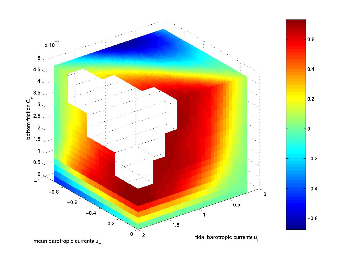
I have conducted extensive observational studies of the circulation and salinity patterns in the area, looking at variations both in space (along and across the channel) and in time (over the tidal cycle). The observations raised new questions, which I have addressed with new models of along-channel circulation in two and three layers. My models are relatively simple, and I have used them to simulate, not only conditions at the Columbia River bar, but also a wide variety of other conditions. Here's a teaser plot, the best one from my thesis papers. In the red zone, the pycnocline is thicker on ebb than on flood, as observed in most natural systems. In the blue zone, the pycnocline is thicker on flood. If you get to this part of my page, please e-mail me for an explanation.
Take a look at my two publications written with David Jay in 1999. Copies are available on request. Here's the abstract for my Ph.D. thesis, which I submitted in May of 1998. Here is a writeup, just two paragraphs and some cool figures, on the status of my research as of late 1997.